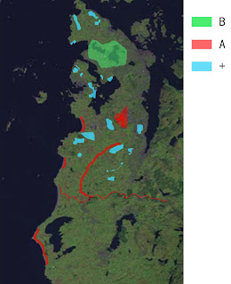
I did some analysis about Jaeren that the three different types of land: A. +. B. I through found some information about these main land, try to find my themes.
A. The characteristic is: linear features based corridor: channels、rivers、beaches、wetland. The main problem is the sea level rise impact the corridor. For example: beaches are slowly eaten by tides and seastorms、river and channels have been over exploited for agriculture, and are now seriously polluted.
The theme: leisure tourism and corridor protection.
B. The characteristic is: land use and development. How to balance the residenrial and land use and develpment. Other factors are sea-level rise、climate change、changes in agricultural production.
The theme: dynamic landscape planning and sustainable design
+. Oil resources decline, in the post-oil industry background, replacement of industrial land and ecological restoration and protection、develpment strategy.
The theme: industrial land、landscape protection and restoration of the design.


Dear Rong
ReplyDeleteYour text and map is a first step, seeing Jæren from above. You have to do a twin research. Bottom up, so to speak - Zoom in and consentrate on one or to characteristics. Clearify your first step research with a diagram or two that is more imbedded with information. Carve out a first position of yours, so to speak. And remember - come up with a couple of more elaborate arguments (see Alices assignment 1 poster) when you do this. If you read Ellen Braaes little blogpost "looking for change" you see that you dont need to be afraid of more information, gather anything that comes in your way. If you also read my text on "Thouching the agriculture .." etc you will find that I work with a series of people to highten my level of understanding - charge some more energy into your findings and make a smart diagram of this. I think Alice also will comment this map of yours.
KED
Dear Rong -
ReplyDeleteas wei discussed earlier this week, drawing this map you have selected to analyse places that you found important because they were identified as critical from the first research projects. This in an interesting starting point. Now you have to argument why, overlap you own thought to the already delivered answers from the former students. As Knut Eirik says, now you should go down in the scale of your analysis: choose one/two/three frames and analyse the discrete territories you have higlighted in your map. With orthophotos, simple maps and diagrams. Are you still searching for a new relationship between water and its borders to the land in a paerspective of climate change? Go for it, but be sharp and think in your thoughts, really investigate the consequences and possibilities, even bringing back that chinese littoral project, or any other reference that comes to your mind.. Can be as visionary as this project from Rietveld Landscape: http://www.rietveldlandscape.com/en/projects/105
good luck! -a